The Weather Bark From WeatherFox
Elko Nevada Weather - WeatherFox's Home Den.
Elko Nevada, Elko County & Regional Weather, Cameras, News, & More

Weather Alerts
Issued by the National Weather Service

Extreme Heat Warning EXTREME HEAT WARNING Extreme Heat Warning

Areas Affected:
Northern Lander County and Northern Eureka County - Southern Lander County and Southern Eureka County - Southwest Elko County - Northwestern Nye County - Northeastern Nye County
Effective: Sat, 8/8 9:42pm Updated: Sat, 8/8 10:05pm Urgency: Expected
Expires: Sun, 8/9 2:00pm Severity:  Severe  Certainty: Likely

 
Details:
* WHAT...High temperatures 100 to 105 degrees in the valleys each
afternoon. Low temperatures 62 to 70 degrees in the valleys each
night. This will result in a major risk for heat-related illnesses
for much of the population, especially those without effective
cooling.

* WHERE...Northern Lander and Northern Eureka, Southern Lander and
Southern Eureka, Southwest Elko, Northeastern Nye, and
Northwestern Nye Counties.

* WHEN...Until 11 PM PDT Sunday.

* IMPACTS...Heat related illnesses increase significantly during
extreme heat

Information:
Drink plenty of fluids, stay in an air-conditioned room, stay out of
the sun, and check up on relatives and neighbors.

Do not leave young children and pets in unattended vehicles. Car
interiors will reach lethal temperatures in a matter of minutes.

Take extra precautions when outside. Wear lightweight and loose
fitting clothing. Try to limit strenuous activities to early morning
or evening. Take action when you see symptoms of heat exhaustion and
heat stroke.

To reduce risk during outdoor work, the Occupational Safety and
Health Administration recommends scheduling frequent rest breaks in
shaded or air conditioned environments. Anyone overcome by heat
should be moved to a cool and shaded location. Heat stroke is an
emergency! Call 9 1 1.

Extreme Heat Warning EXTREME HEAT WARNING Extreme Heat Warning

Areas Affected:
South Central Elko County
Effective: Sat, 8/8 9:42pm Updated: Sat, 8/8 10:05pm Urgency: Expected
Expires: Sun, 8/9 2:00pm Severity:  Severe  Certainty: Likely

 
Details:
* WHAT...High temperatures 100 to 105 degrees in the valleys each
afternoon. Low temperatures 73 to 78 degrees in the valleys each
night. This will result in a major risk for heat-related illnesses
for much of the population, especially those without effective
cooling.

* WHERE...South Central Elko County.

* WHEN...Until 11 PM PDT Sunday.

* IMPACTS...Heat related illnesses increase significantly during
extreme heat.

Information:
Take extra precautions when outside. Wear lightweight and loose
fitting clothing. Try to limit strenuous activities to early morning
or evening. Take action when you see symptoms of heat exhaustion and
heat stroke.

To reduce risk during outdoor work, the Occupational Safety and
Health Administration recommends scheduling frequent rest breaks in
shaded or air conditioned environments. Anyone overcome by heat
should be moved to a cool and shaded location. Heat stroke is an
emergency! Call 9 1 1.

Do not leave young children and pets in unattended vehicles. Car
interiors will reach lethal temperatures in a matter of minutes.

Drink plenty of fluids, stay in an air-conditioned room, stay out of
the sun, and check up on relatives and neighbors.

Extreme Heat Warning EXTREME HEAT WARNING Extreme Heat Warning

Areas Affected:
Southeastern Elko County
Effective: Sat, 8/8 9:42pm Updated: Sat, 8/8 10:05pm Urgency: Expected
Expires: Sun, 8/9 2:00pm Severity:  Severe  Certainty: Likely

 
Details:
* WHAT...High temperatures 100 to 105 degrees in the valleys each
afternoon. Low temperatures 73 to 78 degrees in the valleys each
night. This will result in a major risk for heat-related illnesses
for much of the population, especially those without effective
cooling.

* WHERE...Southeastern Elko County.

* WHEN...Until 11 PM PDT Monday.

* IMPACTS...Heat-related illnesses increase significantly during
extreme heat events.

Information:
Take extra precautions when outside. Wear lightweight and loose
fitting clothing. Try to limit strenuous activities to early morning
or evening. Take action when you see symptoms of heat exhaustion and
heat stroke.

To reduce risk during outdoor work, the Occupational Safety and
Health Administration recommends scheduling frequent rest breaks in
shaded or air conditioned environments. Anyone overcome by heat
should be moved to a cool and shaded location. Heat stroke is an
emergency! Call 9 1 1.

Do not leave young children and pets in unattended vehicles. Car
interiors will reach lethal temperatures in a matter of minutes.

Drink plenty of fluids, remain in an air-conditioned room, stay out
of the sun, and check on relatives and neighbors.

Heat Advisory HEAT ADVISORY Heat Advisory

Areas Affected:
Northern Elko County - Ruby Mountains and East Humboldt Range - White Pine County
Effective: Sat, 8/8 9:42pm Updated: Sat, 8/8 10:05pm Urgency: Expected
Expires: Sun, 8/9 2:00pm Severity:  Moderate  Certainty: Likely

 
Details:
* WHAT...High temperatures 100 to 105 degrees in the valleys each
afternoon.

* WHERE...White Pine, Northern Elko, and Ruby Mountains and East
Humboldt Range in Elko Counties.

* WHEN...Until 11 PM PDT Sunday.

* IMPACTS...Hot temperatures may cause heat illnesses.

Information:
Drink plenty of fluids, remain in an air-conditioned room, stay out
of the sun, and check on relatives and neighbors.

Today's Forecast Map
Click Map To Enlarge & See More Maps
Click Map To Enlarge     Image from NOAA
Current Satellite
Click Map To Enlarge
Click Map To Enlarge     Image from NOAA
Current Weather & Forecasts

Elko    Elko Airport    Ryndon    Spring Creek    Lamoille    Carlin    Adobe Heights    Wild Horse    Mountain City    Owyhee

Ruby Valley    Deeth    Halleck    Wells    Bishop    O'Neil    Jackpot    Palomino Valley    Pequop Summit    Pilot Valley

Loray    Montello    Wendover    Jarbidge    Eureka    Ely    Crescent Valley    Battle Mountain    Tonopah    Winnemucca

Austin    Winnemucca    Reno    Twin Falls    Salt Lake City    Pahrump    Las Vegas    Pendleton    Boise    Portland

Goldstrike Mine    Cortez Mine    Turquoise Ridge Mine    Round Mountain    Seattle    Truckee    Spokane

Forecast Maps    Forecast Discussion

National Weather Service Elko, NV    Climate Prediction Center    Weather Glossary

Alerts provided by the National Weather Service.

Weather Alerts Map
Alerts provided by the National Weather Service.

Weather Alerts Definitions
OUTLOOK
A weather outlook gives you a heads up, there is potential for a significant storm two, three,
four, or perhaps five days in advance. This is your first chance to begin preparing for the event.

SPECIAL WEATHER STATEMENT
A special weather statement may be issued for hazards that have not yet reached
advisory or warning status or that do not have a specific code of their own.

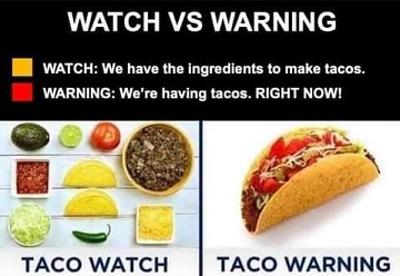
WATCH
A watch is issued a day or two prior to the anticipated significant weather event. Odds of the event
have increased yet some uncertainty remains for the forecast area. Time to get ready, get prepared.

ADVISORY
A advisory is for weather events with up to 24 hour lead time that are more of an inconvenience and
not necessarily life-threatening. A winter weather advisory for one or two inches of snow is an example.

WARNING
A warning means confidence is high the significant weather event will occur within the
next 24 hours or less, or is underway. Time to take action to help save lives and property.
Alerts provided by the National Weather Service.

Current Time    10:12 PM Pacific    11:12 PM Mountain    12:12 AM Central    1:12 AM Eastern    05:12 UTC

Home     Mobile Site     SiteMap     About & Contact

Listen to NOAA Weather Radio

9 visitors currently viewing this site.

USA Weather Finder

Home Den Of The World Famous WeatherFox.
Unauthorized duplication or distribution is prohibited.
Copyright © 2003 - 2026 nvwx.com
WeatherFox is a non-meteorologist spokesfox.
Weather forecasts are provided by the National Weather Service.
Weather data from this station is accurate and up to date as possible, equipment failures,
internet issues, weather and/or other conditions may affect the accuracy of the data shown.
Use this and any weather data, forecasts, and images with caution and at your own risk.
Privacy Policy