The Weather Bark From WeatherFox
Elko Nevada Weather - WeatherFox's Home Den.
Elko Nevada, Elko County & Regional Weather, Cameras, News, & More

Spokane Washington Weather
10:02 AM

Temperature: 43°F

Humidity: 61%

Wind: SSE @ 6 mph

Sky: Overcast Clouds

Spokane Weather Details

Radar & Satellite

Road Cameras - I-90

Spokane, WA
Spokane, WA I-90 at MP 287.8
Road Cameras - I-90

Spokane Washington Weather Forecast
Updated at: 2:16 am PST Nov 03, 2026 From the NWS Spokane, WA.
Today

Today: Mostly Cloudy
Mostly Cloudy
Hi 50 °F
Tonight

Tonight: Mostly Cloudy
Mostly Cloudy
Lo 35 °F
Wednesday

Wednesday: Mostly Sunny
Mostly Sunny
Hi 50 °F
Wednesday
Night
Wednesday Night: Mostly Cloudy then Rain Showers Likely
Mostly Cloudy then Rain Showers Likely
Lo 36 °F
Thursday

Thursday: Rain Showers Likely
Rain Showers Likely
Hi 49 °F
Thursday
Night
Thursday Night: Mostly Cloudy then Slight Chance Rain Showers
Mostly Cloudy then Slight Chance Rain Showers
Lo 35 °F
Friday

Friday: Slight Chance Rain Showers then Mostly Cloudy
Slight Chance Rain Showers then Mostly Cloudy
Hi 52 °F

Friday
Night
Friday Night: Mostly Cloudy
Mostly Cloudy
Lo 37 °F
Saturday

Saturday: Partly Sunny
Partly Sunny
Hi 55 °F
Saturday
Night
Saturday Night: Mostly Cloudy then Slight Chance Rain Showers
Mostly Cloudy then Slight Chance Rain Showers
Lo 39 °F
Sunday

Sunday: Slight Chance Rain Showers then Mostly Cloudy
Slight Chance Rain Showers then Mostly Cloudy
Hi 54 °F
Sunday
Night
Sunday Night: Mostly Cloudy
Mostly Cloudy
Lo 38 °F
Monday

Monday: Mostly Cloudy then Slight Chance Rain Showers
Mostly Cloudy then Slight Chance Rain Showers
Hi 54 °F
Monday
Night
Monday Night: Chance Rain Showers
Chance Rain Showers
Lo 38 °F
Today

Today: Mostly Cloudy
Mostly Cloudy
Hi 50 °F
Mostly cloudy. High near 50, with temperatures falling to around 46 in the afternoon. Northeast wind around 5 mph.
Tonight

Tonight: Mostly Cloudy
Mostly Cloudy
Lo 35 °F
Mostly cloudy, with a low around 35. Northwest wind around 2 mph.

Wednesday

Wednesday: Mostly Sunny
Mostly Sunny
Hi 50 °F
Mostly sunny. High near 50, with temperatures falling to around 45 in the afternoon. South wind around 3 mph.
Wednesday
Night
Wednesday Night: Mostly Cloudy then Rain Showers Likely
Mostly Cloudy then Rain Showers Likely
Lo 36 °F
Rain showers likely after 4am. Mostly cloudy, with a low around 36. South wind around 3 mph. Chance of precipitation is 70%. New rainfall amounts less than a tenth of an inch possible.

Thursday

Thursday: Rain Showers Likely
Rain Showers Likely
Hi 49 °F
Rain showers likely before 4pm. Mostly cloudy, with a high near 49. South wind 3 to 8 mph. Chance of precipitation is 70%. New rainfall amounts less than a tenth of an inch possible.
Thursday
Night
Thursday Night: Mostly Cloudy then Slight Chance Rain Showers
Mostly Cloudy then Slight Chance Rain Showers
Lo 35 °F
A slight chance of rain showers after 4am. Mostly cloudy, with a low around 35. Chance of precipitation is 20%.

Friday

Friday: Slight Chance Rain Showers then Mostly Cloudy
Slight Chance Rain Showers then Mostly Cloudy
Hi 52 °F
A slight chance of rain showers before 10am. Mostly cloudy, with a high near 52. Chance of precipitation is 20%.
Friday
Night
Friday Night: Mostly Cloudy
Mostly Cloudy
Lo 37 °F
Mostly cloudy, with a low around 37.

Saturday

Saturday: Partly Sunny
Partly Sunny
Hi 55 °F
Partly sunny, with a high near 55.
Saturday
Night
Saturday Night: Mostly Cloudy then Slight Chance Rain Showers
Mostly Cloudy then Slight Chance Rain Showers
Lo 39 °F
A slight chance of rain showers after 4am. Mostly cloudy, with a low around 39. Chance of precipitation is 20%.

Sunday

Sunday: Slight Chance Rain Showers then Mostly Cloudy
Slight Chance Rain Showers then Mostly Cloudy
Hi 54 °F
A slight chance of rain showers before 10am. Mostly cloudy, with a high near 54. Chance of precipitation is 20%.
Sunday
Night
Sunday Night: Mostly Cloudy
Mostly Cloudy
Lo 38 °F
Mostly cloudy, with a low around 38.

Monday

Monday: Mostly Cloudy then Slight Chance Rain Showers
Mostly Cloudy then Slight Chance Rain Showers
Hi 54 °F
A slight chance of rain showers after 4pm. Mostly cloudy, with a high near 54. Chance of precipitation is 20%.
Monday
Night
Monday Night: Chance Rain Showers
Chance Rain Showers
Lo 38 °F
A chance of rain showers. Mostly cloudy, with a low around 38. Chance of precipitation is 30%.

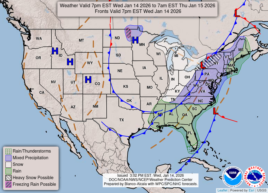
Today's Forecast Map
Click Map To Enlarge & See More Maps
Click Map To Enlarge     Image from NOAA
Current Satellite
Click Map To Enlarge
Click Map To Enlarge     Image from NOAA
Current Weather & Forecasts

Elko    Elko Airport    Ryndon    Spring Creek    Lamoille    Carlin    Adobe Heights    Wild Horse    Mountain City    Owyhee

Ruby Valley    Deeth    Halleck    Wells    Bishop    O'Neil    Jackpot    Palomino Valley    Pequop Summit    Pilot Valley

Loray    Montello    Wendover    Jarbidge    Eureka    Ely    Crescent Valley    Battle Mountain    Tonopah    Winnemucca

Austin    Winnemucca    Reno    Twin Falls    Salt Lake City    Pahrump    Las Vegas    Pendleton    Boise    Portland

Goldstrike Mine    Cortez Mine    Turquoise Ridge Mine    Round Mountain    Seattle    Truckee    Spokane

Forecast Maps    Forecast Discussion

National Weather Service Elko, NV    Climate Prediction Center    Weather Glossary

Forecast provided by the National Weather Service.

Current Time    10:22 AM Pacific    11:22 AM Mountain    12:22 PM Central    1:22 PM Eastern    18:22 UTC

Home     Mobile Site     SiteMap     About & Contact

Road Conditions

30 visitors currently viewing this site.

USA Weather Finder

Home Den Of The World Famous WeatherFox.
Unauthorized duplication or distribution is prohibited.
Copyright © 2003 - 2026 nvwx.com
WeatherFox is a non-meteorologist spokesfox.
Weather forecasts are provided by the National Weather Service.
Weather data from this station is accurate and up to date as possible, equipment failures,
internet issues, weather and/or other conditions may affect the accuracy of the data shown.
Use this and any weather data, forecasts, and images with caution and at your own risk.
Privacy Policy